ecosystem-guides
....exploring the planet's ecosystems
INDO-MALAYAN
Tropical Dry (Deciduous/Monsoon) Forest & Woodlands
The tropical and subtropical dry deciduous and monsoon forest of tropical Asia...
 (Kulen Promtep, Cambodia)
This map shows the distribution of dry forest on the south-east Asian mainland, but it also extends to patches in Java and Bali. Dry forest further east of here belongs to the Wallacean dry forest.
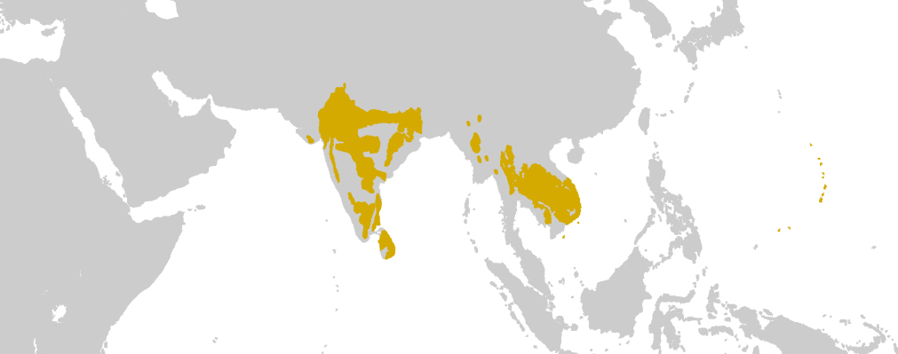 Distribution of Indo-Malayan Dry Forest (By Terpsichores - Own work, CC BY-SA 3.0, https://commons.wikimedia.org/w/index.php?curid=22441311)
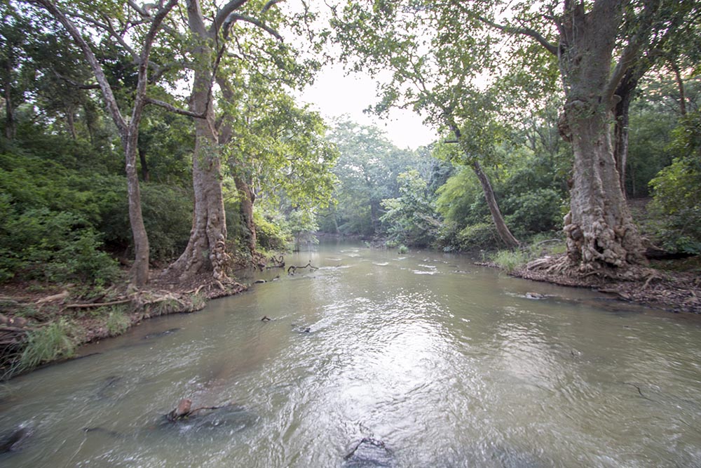
The physical structure can also vary; at the drier end of the open forest, the trees are further apart and the fields are more extensive, and the biome segues into a savanna grassland or dry xeric shrubland. At the wetter end of the scale (such as along rivers as in the image below), the trees start to form a canopy and become a riverine forest; in even wetter areas, it becomes a rainforest.
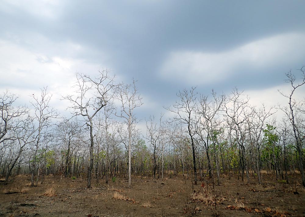
 Lunugamvehera National Park, Yala, Sri Lanka.
Below is the tropical deciduous woodlands of south-east Asia at the end of the dry season, just at the start of the first rains. At this time of the year, many of the dominant trees are leafless.
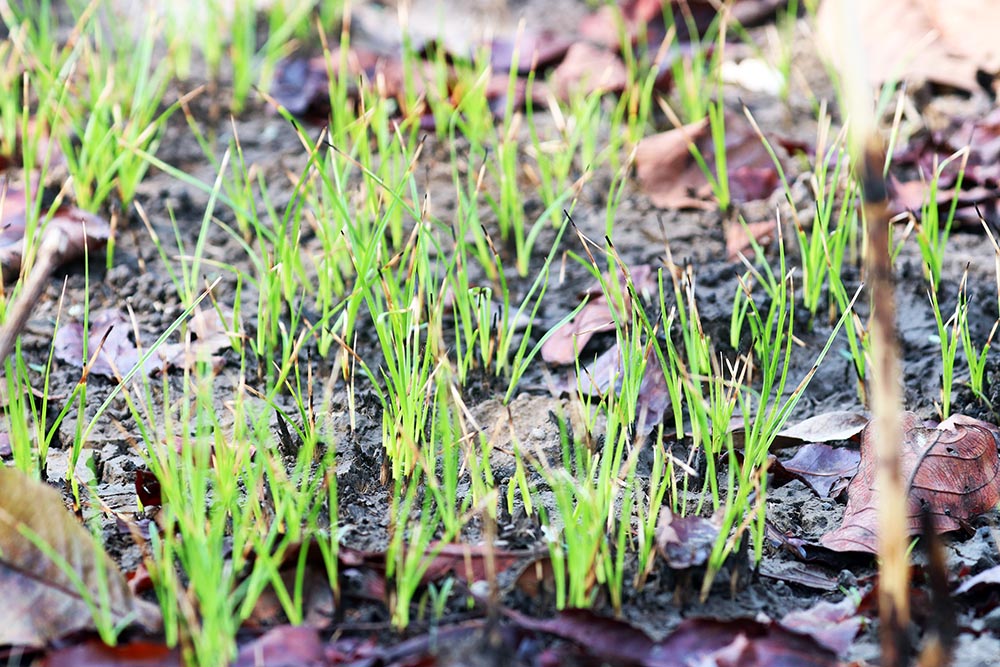
 (Cambodia)
The first rains of the summer monsoon season produce the initial carpet of bright green grass.
The open grassy areas still support groups of herbivores in protected areas.

Legumes are common as trees and shrubs in these drier forests. Below are the yellow flowers and pods of a Cassia.

Unlike the wetter forests where moisture is plentiful and plants commonly produce fleshy fruits, here the drier forests and woodlands produce harder woody fruits. The pods and seeds of legumes and dipterocarps are common on the dry forest floor. Below is Pterocarpus sp. 'Padauk',
 (Kulen Prontemp, Cambodia)
As dominant as they are in the adjacent rainforest, Dipterocarps are are even more obvious in these drier forests.


Most people think of the African savanna when they hear about 'Dung Beetles' (mostly of the subfamily Scarabaeinae), but in fact they widespread throughout much of the world, including the Asian dry forests & woodlands.
 (Yala, Sri Lanka)
The 'dragons' of the family Agamidae includes various often seen species in these habitats, including the widespread and adaptable Calotes versicolor, the 'Oriental/Changeable Garden Dragon/Lizard'. It develops a bright red throat in breeding season.
 (Yala National Park, Sri Lanka)
Draco species known as 'Gliding Lizards' are perhaps slightly easier to see in the drier forest than the wet forest. The males display a bright flap of skin from their neck, the gular flap. These lizards get their name from the fact that they can glide long distances using their wing-like patagia; stretched skin supported by elongated thoracic ribs.
 Gliding Dragon, (Bali Barat, Indonesia)
Butterfly Lizards (of the subfamily Leiolepidinae) live in open areas, where they construct burrows which they duck into quickly when they are alarmed.
 'Butterfly Lizard', (Kulen Prontemp, Cambodia)
The largest of all lizards in these habitats are the monitors of the family Varanidae. One of the more common species seen is Varanus bengalensis, 'Indian/Land/Bengal Monitor'. It is found in India, the middle east, and into south-east Asia.
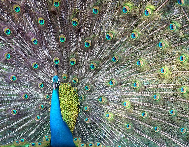
 (Yala National Park, Sri Lanka)
The largest ground birds of the open woodlands are the pheasants of the family Phasianidae. The most spectacular native is of course the Pavo cristatus, 'Indian Peafowl'. Endemic to India and Sri Lanka, but introduced to many other places around the world.
Tall, but still and dull to blend in with their habitat are the 'Thick-knees' of the family Burhinidae, such as the below Burhinus indicus, 'Indian Stone-Curlew/Thick-knee'.
 Indian Thick-knee (Udawalawa National Park)
Several species of Ibis of the family Threskiornithidae have evolved to live in the dry woodlands of tropical Asia rather than their usual wetland habitat. Both the 'Giant Ibis' and the 'White-shouldered Ibis' are considered rare today.
 White-shouldered Ibis, (Kulen Prontemp, Cambodia)
The family Accipitridae contains the Hawks, Kites, and Eagles. These are major predators, as below with the '(Sri Lankan Crested) Changeable Hawk-eagle', Nisaetus cirrhatus ceylanensis.
 Don't you hate it when the strands of pizza cheese are so sticky? (Yala National Park, Sri Lanka)
The bee-eaters of the family Meropidae are, as the name suggests, insect eaters, often perching on branches in the open and flying out to catch prey such as dragonflies. They are among the most colourful and obvious of small bids in the tropical Asian woodlands. Below is the 'Blue-tailed Bee-eater', a species that is widespread in open habitats throughout Indian region and south-east Asia.
 (Yala. Sri Lanka)
Another classic and colourful bird of the tropical open woodlands is Coracias benghalensis, 'Indian Roller', which is found from the middle east, across India, to tropical south-east Asia.
 Indian Roller (Bundala, Sri Lanka)
The woodpeckers of the family Picidae are surpisingly diverse in the more pristine open woodlands of tropical Asia. They range in shape, colour, size and ecological niche. They include the largest definitely extant Woodpecker the 'Great Slaty Woodpecker'.
 'Black-headed Woodpecker' (Kulen Prontemp, Cambodia)
 'Great Slaty Woodpecker'.
The family Psittaculidae includes the Old World Parrots. In the tropical open woodland, species include:
 'Rose-ringed/Ring-necked Parakeet' (Bundala, Sri Lanka).
 'Red-breasted Parakeet', (Kulen Prontemp, Cambodia)
As in the adjacent forests, one of the most important and obvious groups of songbirds in the tropical Asian dry forest and woodlands are the 'Bulbuls' of the Family Pycnonotidae.
 'Black-crested Bulbul', (Khao Yai National Park, Thailand).
One of the prettiest types of birds, and important pollinators, are the Sunbirds of the family Nectariniidae.
 'Purple Sunbird', (Sri Lanka).
Prehistorically, there were many species living here in these drier open habitats, related and equivalent to the Afrotropical savanna. But fast clearing and recent development has had an negative effect. Nevertheless, in some protected areas, the more open woodlands of tropical Asia can be good for mammal viewing, especially in the subcontinent of India and the connected island of Sri Lanka.
The largest mammal species here are of course the Elephants of the family Elephantidae. There are three recognised living species; two in Africa, and one in Asia. Of the latter, there are three subspecies of Elephas maximus, including indicus, the '(Indian) Asian Elephant', (below: a mother with young). Elephants eat tree bark, twigs, fruits, grass and roots, and might gobble up to 150 kilograms of food every day, so they are obviously an important herbivore in these open habitats.
 Indian Elephant (Udawalawa national park, Sri Lanka)
Besides elephants, there are other large mammalian herbivores, such as the Gaur, the largest cattle species in the world.

And several slimmer grazers and browsers...
 'Spotted Deer', (Lunugamvehera National Park, Sri Lanka).
 'Common Muntjac Deer', (Bali Barat National Park, Indonesia).
The primate order includes the Old World Monkey family the Cercopithecidae. The most common and obvious group of open habitat monkeys are the 'Macaques'...
 'Long-tailed Macaque' (Bali Barat).
 'Toque Macaque'. Endemic to Sri Lanka (Bundala, Sri Lanka).
Semnopithecus spp. the 'Grey Langurs' are long limbed and usually greyish. As a group, they are mostly found in the open habitats of India and Sri Lanka. They usually feed on leaves, but have been recorded eating grass, fruit, seeds, insects and larvae, and taking hand-outs from their relatives, humans. Below is Semnopithecus priam, the 'Tufted Gray Langur'

The family Sciuridae of the order Rodentia contains all the squirrels of the world.
 'Variable Squirrel', (Angkor Wat, Cambodia).
 'Cambodian Striped Squirrel', (Kulen Prontemp, Cambodia).
And on top of the food chain are the predators of the Order Carnivora. The King is of course Panthera tigris, the 'Tiger'.
 (Kanha, India)
Another stunning predator of these habitats is Panthera pardus, the 'Leopard'. It has a strange saw-like back and forth roar (that I have heard while hiding in my tent in India). It was one of the few big cats that still has a wide distribution; this species is found across tropical Africa and Asia.
 (Lunugamvehera National Park, Sri Lanka)
There are also many smaller species, including Herpestes smithii, 'Ruddy Mongoose' of Sri Lanka and India. While they are often recorded in the forest, they are perhaps more easily spotted in open habitats.
")
Places to experience dry forest & woodland of tropical Asia
India has the largest most intact areas of dry woodland, including the famous Kanha National park in the centre of India, and Periyar National Park in the tropical south. Off the tip of India is the less populated Sri Lanka. For woodlands, go to Lunugamvehera National Park, Udawalawa National Park and Yala National Park.
Mainland south-east Asia is rapidly losing its drier woodlands. Protected areas in Cambodia include: Florican Grasslands, Kulen Prontemp, and one of the few places to stay is Tmatboey Lodge. One of the more accessible protected areas is Khao Yai National Park in Thailand, just a few hours outside of Bangkok.
About the author

Written by Damon Ramsey. All photographs by author (unless credited otherwise). This is not AI written. Images and information are added to this website continuously as of 2026. Feel free to copy photographs for educational purposes, but please acknowledge with: www.ecosystem-guides.com. Ecosystem Guides posts pretty shots on Instagram and some sillier photos on Facebook. Contact Email: damon@ecosystem-guides.com
Search this website (and the wider internet):
For books in the "Ecosystem Guides" series on Amazon (international) click on the book cover below
(or go to your country specific Amazon website to order, for example, click here for Amazon Australia)


